.jpg)
Damavand Mountain
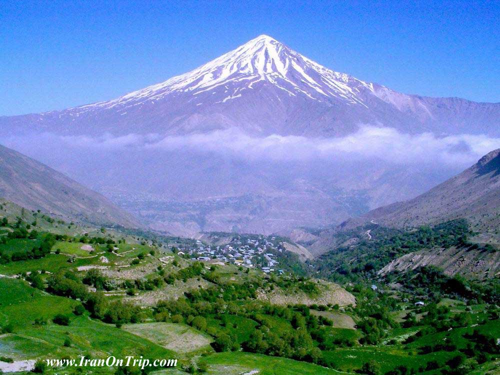
Mount Damavand, is a potentially active volcano or Stratovolcano and the highest peak in Iran, and has a special place in Persian mythology and folklore.Elevation: 18,602' (5,671 m)
Prominence: 15,312' (4,667 m)
Mountain range: Alborz
First ascender: Abu Dolaf Kazraj
A dormant volcano with a narrow summit. Location Alborz Mountains, Iran. Height 5671.
The earliest recorded ascent of Damavand was made in 905 by Abu Dolaf Kazraji, although others unknown may have preceded him. Three centuries later Yaqut, the great Byzantine/Arab geographer, attempted to climb Damavand, but failed to reach the summit. However, the local people who served him as guides gave him a detailed description of the summit which he incorporated into his famous "Dictionary of Geography", and which conforms perfectly with the geographical reality. At approximately the same time Ebn Esfandiar noted that the ascent from Ask took around two days. Apparently climbs of Damavand were not uncommon during the early 13th century, before the Mongol invasion under Hulagu Khan swept, and destroyed, everything before it.
actually, at the time of Thompson's ascent in 1837, there were ascents regularly being made by iranians, to gather sulphur from the summit for commercial purposes; Thompson himself mentions this in his article in the Royal Geographic society magazine of 1838. This commercial activity was mentionned in Nasser-i Khosrow's medieval book of travels
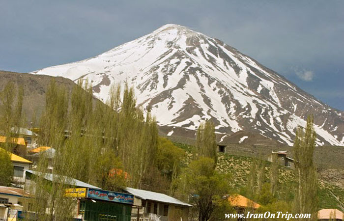
The seasoned traveler in Iran is so used to seeing gaunt, rugged precipice , jagged peaks and bare deserts, that the sight of Damavand is a relief and surprise to the eye. Visible From many kilometers away, thought it is surrounded on every side by the peaks and ridges of the albroz, its superior height and singular outline compel attention. It is as prominent a feature in northern Iran (only 80-km northeast of the capital, Tehran) as is the well-known Fujiyama in Japan. Many travelers say that its snowy-white cone is the most beautiful sight of the country and the one-day treasure most.
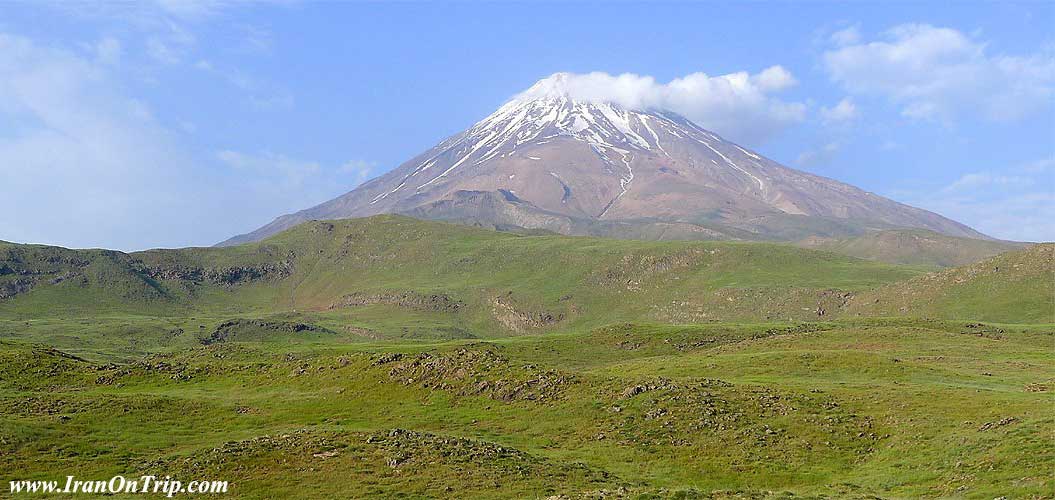
A small and picturesque town bearing the name of Damavand is beautifully situated on the southern slopes and is much used as a summer resort by the people of Tehran. There has been no eruption of the mountain in historical times and it is now regarded as virtually extinct thought some hot springs are found on its lower slopes. At the summit there is a crater, some 300 meters across, with a profusion of yellow sulfurous rocks and pumice stones. Snow covers the crater and upper slopes in winter and spring. in sheltered hollows snow many remain all the year. On most days of the year the summit can be seen from Tehran and, when the air is clear from far away kasahn to the south of the great salt desert.It is not surprising that such a prominent mountain should figure in Iranian legend. The great tenth-century Iranian poet, Firdausi, relates in his epic “Shahnama” how the tyrant Zohak is overthrown by the young Feridun and imprisoned in chains to die in a cavern on the slops of Damavand. Local legend asserts that his groans may still be heard .
on this slops lived the heroes, Jemshid and Rostem .On Other Legend Associated Damavand with the arc, claiming that it rested here, and not ararat.
Damavand has been frequently climbed.Traditionally, the Iranian was opposed to the conquest of the mountain. The climb is long, but not difficult or dangerous. Loose stone and small ribs of rock have to be clambers over, at higher levels, if the accent in early summer, expanses of snow must be corset to the crater at the top. Because of its great height and isolation, the view from Damavand is very extensive; a vast panorama of mountains, valley and desert covering many handed of square Kilometers. All around are other peaks of the alborz range, sweeping down in the north to the humid Caspian plain and in the south descending to the deserts of central of iran
Fact Box
Other names/spellings Demavend
Køh-e Damavand
Demavend Kuh
Mount Demavend
Mount Damavand
Elevation (feet) 18,602
Elevation (meters) 5,671
Location Aborz Mountains Iran
Latitude 35° 57' 21" N
Longitude 52° 06' 31" E
Best Climbing Months July, August, September Year First Climbed 1837
First Climber(s) W.T. Thomson
volcanic Status Active
Most Recent Eruption None on record
Convenient Center(s) Raineh, Iran (village at the south base of the mountain)
Nearest Major Airport Teheran, Iran
Relief map
Recommended
Mountain Clothing
Recommended
Mountain Equipment
Warm, wind proof jacket with hood - Good warm sleeping bag
Waterproof jacket and over-trousers Water bottle (1 -to 2 litres)
Walking trousers, shirts, pullover Water purification tablets and filter
Warm underwear Wash kit, towel, toilet paper
Walking socks First aid kit ( including blister plasters, lip slave
Good comfortable Climbing boots headache pills, sun cream, personal medication)
Trainers ( for evenings) Torch
Gaiters Sun glasses
Sun hat Walking pole (s)
Warm hat or balaclava and scarf
NB: It is advisable to pack your clothing and equipment into a waterproof rucksack for carry. Also it is advisable to have a small day rucksack to carry your raincoat, camera, packed lunch and energy snack and items of personal nature.
Date: July 02, 2001 8:49 PM
Mount Damavand
How to Reach the Summit
By: Reza Chahkanouii
Translation: Massoud Mohsenin
From: Kouh Magazine - Spring & Summer 1996
Alborz Mountain range with more than 2000 Km. lenght lies from North-West to North-East of Iran.
This vast mountain range comprises main peaks of 4000m. height. The only peak higher than 5000m. is Damavand with 5671m. altitude at the farthest end of the central eastern part of Alborz. It's 70Km. on a straight line from Tehran.
Mount Damavand is the result of volcanic activities at the beginning of the quaternary geologic time (Pleistcence stage). The same accured for Arrarat in Turkey and Sahand, Sabalan and Alvand in Iran.
Damavand like many volcanic mountains bears a conic shape very similar to Fujiyama in Japan.
Damavand is actually a non-active volcano but wipes brim-stone. It means that it is going through the last stage before complete silence. However, its warm mineral springs, absence of extensive glaciers and frequent earthquakes at every few years intervals are the evidences of internal activities of this mountain. However, its isolation, high altitude and conic shape visible from far distances, have made it outstanding amongst other high mountains in the region.
Damavand region is one of the most beautiful natural surroundings with fields full of wild poppy and purple lily in spring and long grass plots in green summer. It is also a rainfull area having very hard winters, but moderate summers. The summit and slopes are always covered by snow.
In the history of Iran, Damavand has always been a symbol and its name is synonymous with Iran.
A good number of tales and epics have been written about it, reflecting the deep place it holds in the culture and beliefs of Iranian people.
Due to its conical shape, climbing is possible from all sides, but well-known paths are nine. The most frequented are North, North-East, South and West faces. The easiest trajectory is the southern path. On all faces, shelters are provided.
If the starting point is Tehran, you should count on an average of 3 days for the climb. From Tehran, you take Haraz Road. After 120 Km. via Polour village, you reach Reineh village. This is the nearest village to the southern path. There, you can find a well-equipped old shelter.
In the past, climbing started from this village, but nowadays, by taking a dirt road (often used by mine machinery) you can reach a spot called Goosfand- Sara with an altitude of 3200m. from sea level. At this point, you can follow a path with a moderate slope which gets gradually steeper. After 3 to 4 hours climbing, you reach the southern shelter at 4150m. altitude. This shelter with a capacity of 30 persons is a favorable place for a short night rest.
The beginning hours of the following day is the best time to start the final stage of the climb. The path starts from behind the shelter. the slope is relativelysteep and the high altitude and lack of Oxygen makes climbing rather difficult. At 5100m. at your right, you can see a huge suspending ice-piece called Abshar Yakhy (Icy Water Fall).
The most difficult part of the climb is about 300m. under the peak. This part is called Doud Kouh (Smoke Mountain) or Sulphuric Hill, steaming sulphuric gas out of the holes. Its bad smell makes breathing difficult. After passing this part, there is no more slope to climb, only a huge ditch waits ahead. This is the main Damavand volcanic mouth located on top of the summit.
If the weather is fine, you can see the green jungle of the north of Iran, the Caspian sea, the city of Tehran, the lake of Lar and at very far sight on the south the vast plain of Varamin from Damavand peak.
Climbing from shelter to the peak takes 8 to 9 hours and the return to the shelter about 3 to 4 hours.
.....
.....
.....