.jpg)
Tochal Mountain
Mount Tochal is a mountain in the Alborz range and a ski resort adjacent to metropolitan Tehran, Iran. The mountain has a 12 km long ridgeline.
Elevation: 13,005' (3,964 m)
Mountain range: Alborz
The Alborz Mountains form a dense, long and narrow chain that runs through northern Iran separating the Caspian Sea from the central plateau of Iran. The higher peaks of the Alborz exceed heights of 14 to 15 thousand feet with the 15912 ft (4850 m) summit of Mt. Alam (Alam kooh) as the range's second highest peak. The dormant volcanic cone of Mt. Damavand soars far above the rest of the mountains to an elevation of 18606 ft (5671 m) forming the country's highest peak. The proximity of the mountains to the Caspian Sea has created a steamy lush environment on the coastal plain and the northernmost slopes. The rest of the mountains, however, are mostly bare, limiting trees to the banks of the streams at the bottom of the valleys. Grasslands, alpine tundra and permanent snow cover the higher elevations. Winter brings a heavy coat of powdery snow several feet deep creating an ideal environment for skiing.
Mt. Tochal is an integral part of the city of Tehran, where urban and alpine co-exist.
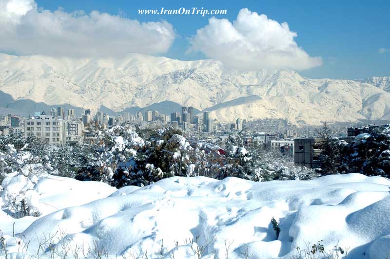
Tehran is a giant city that is home to more than 10 million people. This crowded city has been blessed with an awesome skyline. On a straight line, the 3964 m summit of Mt. Tochal is only 7 Km away from the northernmost neighborhoods of Tehran. At home, at school and in the office, all you have to do is look out the window to get a glimpse of this great mountain.
Mt. Tochal marks the southern boundary of the Alborz Mountains at Tehran's longitude. It rises over a sloped plain where the city of Tehran is located. The city ranges in elevation from around 1800 m at its northern end (where sprawl has driven the neighborhoods up the slopes as far as possible) down to1000 m at the southern end (where it approaches the margins of the central desert of Iran). The summit of Mt. Tochal (known as Sar Tochal) is a high point along the length of a 12 Km long ridgeline that is entirely above 3500 m (much of this ridgeline is higher than 3700m). While the eastern 8 Km of the ridgeline runs east-west and looms directly above northern Tehran, the western 4 Km takes a northwest-southeasterly direction and its view from north Tehran is blocked by lower peaks such as Palang Chal (3520 m) and Doshakh (3045 m) (see topomap).Besides the official summit, other peaks/high points can be defined on the crest of the ridgeline. The most notable of these is the 3876 m summit of Mt. Shah Neshin 3.75 Km to the west of Sar Tochal.
From mid autumn to mid spring, the higher slopes of Mt. Tochal (say above 3000 m) are covered by a thick blanket of snow. Although in winter it does snow in Tehran, the snow usually melts away after a few days of sunshine. The same is true for the south-facing slopes of Tochal below 2400 m. Patches of snow stay on the higher slopes well into early summer. The sight of snow can be an open invitation to those who wish to escape the 40 degrees C temperatures of Tehran's summers. From mid summer through early autumn, the mountain appears brown and barren. At times, city smog can severely limit the view of the mountain.
Several hiking trails start in the northern suburbs and climb the mountain to various elevations. West to east, these include Darakeh, Telecabin, Darband and Kolak Chal. Darband offers the most direct route to the summit. Except for the Telecabin, the rest of the trails follow tree-lined mountain streams at the bottom of valleys where trailside cafes provide a place to rest and enjoy refreshments. During the recent years, mountain hiking has become much more popular. On weekends, scores of people jam-pack the trails. Rock climbing opportunities are also available in many areas the most famous of which are the Bande Yakhchal and Kolak Chal Walls (see Schematic Map). Bande Yakhchal is a huge rocky outcropping that sits to the east of the Darband Valley. It is a few hundred meters high and reaches a top elevation of 3120 m. Kolak Chal Wall, located above the Kolak Chal Shelter, has an elevation of 3340 m on its top. Both of these impressive walls are well-visible from Tehran.
An 8 Km long gondola line (Telecabin) that goes from an elevation of 1900
Top Ski Area
m to a point on the crest of the mountain 3740 m was completed in the late 1970s. At the time, it was claimed to be the world's longest gondola line. There are several ski lifts around the main line: a few over the south-facing slopes near the Gondola's 5th station (2935 m) and two or three over the north-facing slopes near the top station where a hotel has also been built (the higher ski lift goes up to around 3900 m in elevation). The ski season on the top station is said to last until June (for more information go to Tochal.org). Despite its potential, the Tochal ski area has not been fully developed and is unable to compete with the much larger and more popular resorts of Shemshak and Dizin 60 km away.
.....
.....
.....